Getting To Us
Across The Channel The vast majority of our guests come with their own transport via the English Channel so this page focuses on that route. If you would like advice or assistance for any other route please let us know and we will do our best to help. The map below shows the routes but as these can change please check for yourselves that they are still in operation and that they have crossings on your chosen dates. Not all, especially the longer crossings, operate every day throughout the year. Click the map to enlarge it. |
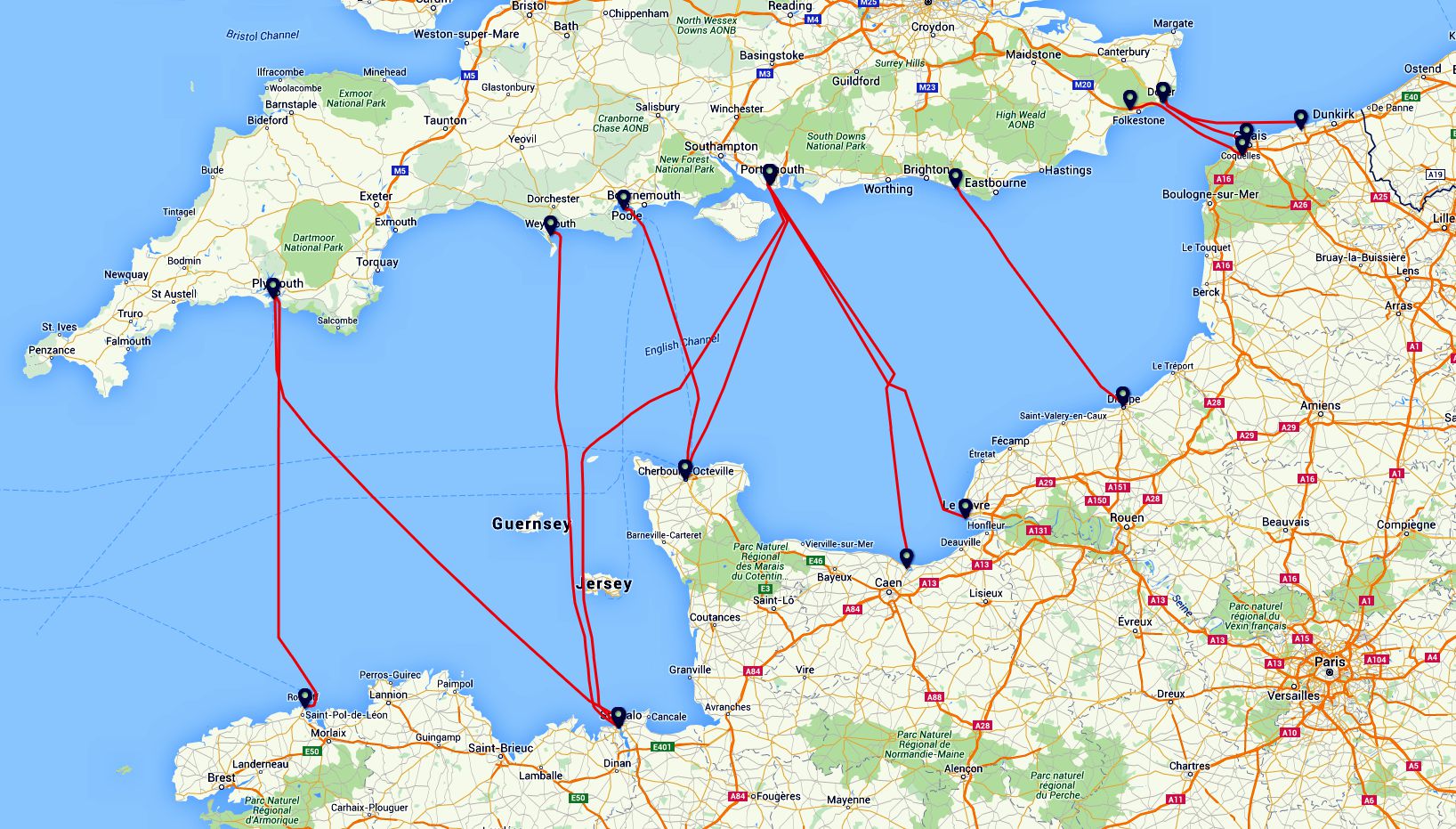
These crossing times are approximate and are only a guide. Disembarkation times vary by route and can be anything between a few minutes to nearly an hour. As an example (and the route is otherwise very good), Newhaven - Dieppe is not a roll on roll off ferry and if you get there early you will probably be parked on the upper deck which means you will be amongst the last off. It doesn't always pay to be first to board! |
If it matters to you, consider paying for a premium booking or whatever your ferry company calls it. This is often very inexpensive but has the added bonus of priority boarding and disembarkation. It's also worth looking to see if you can get a discount from the published fares for, e.g. being over 60. The aforementioned Newhaven - Dieppe crossing offers both these.... but you have to ask. It is not always cheapest to book on the internet. |
| Route | Cross | Time | Time to La Goupillère | Distance | Tolls? |
| Folkestone - Coquelles (Eurotunnel) | 35 minutes | 4 hours | 415 km | Y | |
| Dover – Calais | 1 hours | 30 minutes | 4 hours 10 minutes | 430 km | Y |
| Dover - Dunkirk | 2 hours | 4 hours 30 minutes | 465 km | Y | |
| Portsmouth - Cherbourg | 3 hours | 2 hours 40 minutes | 218 km | N | |
| Newhaven - Dieppe | 4 hours | 2 hours 50 minutes | 279 km | Y | |
| Poole - Cherbourg | 4 hours | 15 minutes | 2 hours 40 minutes | 218 km | N |
| Plymouth - Roscoff | 5 hours | 30 minutes | 3 hours 30 minutes | 340 km | Y |
| Portsmouth - Caen Ouistreham | 5 hours | 45 minutes | 1 hours 50 minutes | 145 km | N |
| Portsmouth - Le Havre | 8 hours | 15 minutes | 2 hours 40 minutes | 215 km | N |
| Plymouth - St Malo | 8 hours | 15 minutes | 2 hours 10 minutes | 160 km | N |
| Portsmouth - St Malo | 11 hours | 2 hours 10 minutes | 160 km | N |
Some ferries at certain times may be "slowed down" to allow a night's sleep. The longer crossings cost more, often considerably more but should be considered part of your holiday, a mini cruise, where you can have a nice meal and a cabin. |
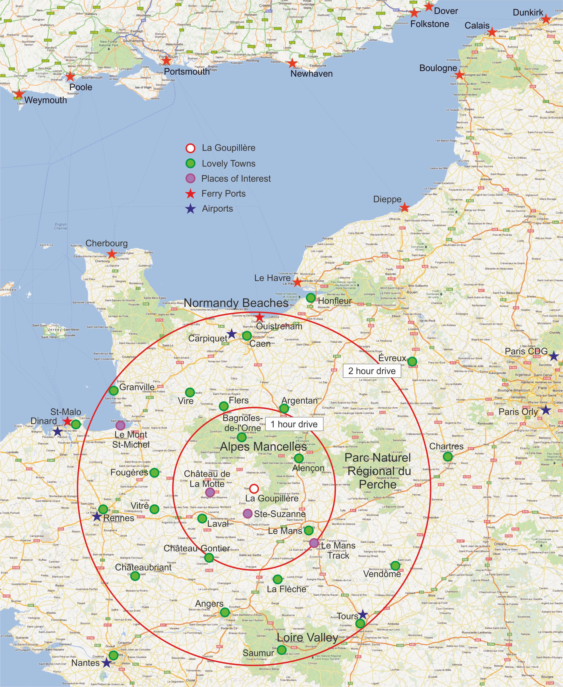
| From the Port to Our Area See the table above for approximate travel times and distances. Obviously the longer you stop along the way the longer you will have to add to these times. Unless you have good reason to do otherwise we recommend that where you can you travel here via motorways as far as Alençon, even though there are tolls. Generally, French motorways have light traffic, are a joy to drive and what you will spend on tolls you will gain in steady progress, better fuel consumption and much less stress. The scenic route has its place of course but unless you are familiar with driving on French country roads or the notoriously dangerous "N" roads, get here safely before you start attempting to overtake juggernauts in your right-hand drive car. Heavy goods vehicles won't pay the tolls so they use the N roads and although there has been much improvement to the Route Nationale system in recent years they are still very busy and often slow moving. There are far too many variations to post meanigful maps here but the one below gives a good guide to La Goupillère in realtion to most ports. Click the map to enlarge it. For a pdf copy click << here >> |
| The Final Leg to La Goupillère You will be sent comprehensive travel information and local maps four weeks prior to your arrival. We have removed the local maps from this website as they served no practical purpose but if you would like copies please just get in touch and, subject to receiving some basic information we will be pleased to email them to you. |